Below is a full textual transcript of what I intended to say, but you can now also watch my actual conference talk as a video

The following slides are also available as the original LibreOffice ODP (76Mb) or as PDF (12Mb).
Jump to slide:
1, 2, 3, 4, 5, 6, 7, 8, 9, 10, 11, 12, 13, 14, 15, 16, 17, 18, 19, 20, 21, 22, 23, 24, 25, 26, 27, 28, 29, 30, 31, 32, 33, 34, 35
Slide 1

Hello my name’s Harry. I’m a long time OpenStreetMap contributor, and today I’m going to talk about “notes”
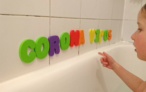
Slide 2

Not this kind of “notes”…although. I do quite like talking about taking notes on paper. When I introduce OpenStreetMap to new people I like to point out that gathering data can involve mobile apps, cameras, GPS units or dictaphones, but it can be a simple as writing some notes on a piece of paper.
…But that’s not what this is about!
Slide 3

OpenStreetMap “Notes” is a feature on the openstreetmap.org homepage, over here on the right. If you click that, you can place a marker and add a little textual description of something which is wrong or missing on the map. For example imagine you live on this street and you notice your local cafe has here has changed it’s name, you might make a note like this.
It’s a very easy way to contribute without needing to learn how to use the editors. You don’t even need to log in.
Slide 4

The “Notes” feature started out around 2009 as this separate website called “OpenStreetBugs” created by user Xav and later re-built by user Emka.
I remember looking at OpenStreetBugs and thinking “I wish I’d thought of that!”. It’s brilliant in its simplicity. A very simple interface to use, and a very simple thing to develop.
The community used it on this separate site for quite a while, but we liked it so much, it was brought onto the main OpenStreetMap site (and bugs data moved over) in 2014.
(Old screenshot found on the mapperz blog)
Slide 5

And here’s where we, as mappers, can consume this information. Tick to enable the “notes” layer here. Then we see red markers for open notes, and sometimes some green markers for recently closed notes. Here’s how it looks in Dundee
Slide 6

And here’s how it looks in central London
In London it’s getting crowded with thousands of notes, so we start to see the limitation of this notes display. It’s showing a maximum 100 notes.
Slide 7

And as we zoom out we see some markers weirdly disappearing from the display. I don’t think it is random, but it seems quite random. And as we zoom out all the way, it stops fetching any notes at all and looks like this. So this kind of gives a summary indication of where some notes data is, but it’s a bit weird.
In this view there are in fact tens of thousands of notes to show, so this would be too much data for the browser to show, or the server to serve, so that’s why we have limits, but it would be nice to have some better overview of all this data when we zoom out.
One solution which may spring to mind is…
Slide 8

“Marker Clusters”. This is a common way of displaying many many data points on web map.
Here we see the MapComplete app in “notes” mode. So they’ve had a go at doing the marker cluster thing on there. We can see little counts across the map showing where there are many notes.
But I often look at marker cluster maps with some frustration/disappointment because when we have loads of data points, this is a missed opportunity for a more much pretty cartographic technique…
Slide 9

A “density map!”
So this is a thing I want to unveil today, created specially for this SOTMEU talk. If we go to https://harrywood.co.uk/maps/notes we can see a density map of OpenStreetMap notes, available as a zoomable tiled map up zoom level 9
Slide 10

It shows closed notes over all time in green, and open notes in red. We can see that cities tend to have a clustering of both closed and open notes. As we’d expect over all time there are more closed that open. So each pixel is showing the intensity notes data. It’s designed to look good on a dark background.
I’m quite proud of this. I’ve always wanted to know how to make a density map like this, and I finally figured it out for the purposes of this talk (It took me a while, although I’m sure there are a few people in this audience who could do this in their sleep!).
Slide 11

I did this using these GDAL tools. Here is my bash script. Actually this is only half the bash script because it does it once for green notes and then again for red notes as two separate layers.
[Update: Here is the full bash script for creating the notes density map]
The fun bit is in the middle here where we define the “colour ramp”. You can see columns here defining the colour levels Red, Green and Blue and then Alpha transparency. So you can see we start off transparent and then the green colour gets more intense, and then for particularly dense areas of notes we fade to white. It’s this which gives it that electric zinging effect.
The last command creates the tiles. I like the way this command spits out the tiles and also a little HTML leaflet map to browse the results.
Slide 12

So going back to the question of what to show on the OpenStreetMap site when we zoom right out. We could make it look something like this, bringing in these tiles. This is just a mock-up of how that would look. I’m only showing red open notes. We could also show some green notes, but for continuity with the markers as you zoom out I suppose ideally it would only show a sprinkling of just the green notes closed in the past week.
Slide 13

Another way of getting an overview of notes, is the stats site by Pascal Neis. There’s lots of great stats on this site, but here’s what the notes section gives as global overview. On the right it’s talking about notes active in the past 10 days, but down the left we have a ranking of countries.
It’s an interesting ranking though because it’s by “opened” notes. Is it good to be high on the rankings of having lots of open notes? It means we’re using notes very actively, but it also might mean we’re not closing them enough.
Slide 14

And we can see if we click on the UK stats, our count of open notes is going up and up. My first instinct would be to worry that we’re not managing to keep up with the notes getting opened. Notes are sitting there unresolved. Surely this is a bad thing.
But we can see there is increasing churn of opened and closed notes each month. I don’t think the situation is very unhealthy. Maybe having lots of notes hanging around, lots of little puzzles to solve, isn’t necessarily a very bad thing.
Slide 15

You may have noticed a patch of intense green on my density map, and this is backed up by the stats for Netherland and Belgium. These countries a both ranking very low on the count of open notes, and we can see they’ve both had periods of steep drops in their notes counts.
Slide 16

They’ve been getting organised about closing lots of notes. In Belgium in particular, you can see a wikipage coordinating resolving notes. They’ve had some face-to-face meet-ups and generally rallied their community around the challenge of resolving notes.
This wiki page has lots of great ideas on it actually. They’ve described some best practices and also suggesting using some hashtags in notes comments, such as #SurveyNeeded
[update: I investigated and found that “#surveyme” is actually a more popular hashtag to use for this]
Slide 17

I also want to shout out to the Colombia OpenStreetMap community and the Latin American community who invented the word “Notathon”, for their coordinated notes closing events. There’s a nice blog post on the main OpenStreetMap blog about this.
They had a big push during lock-down to remotely resolve notes, and we can see in the data, they achieved a big drop!
Slide 18

This brings me onto the idea of whether a note needs a survey to resolve it. Clearly for a lot of notes you can resolve them remotely, hence we can run a “notathon” and have a big organised push to try to close lots of them.
But sometimes there’s no way to resolve a note without going to the place in real life to take a look.
It feels like an important classification, and dividing line between two very different approaches.
Now I’m quite excited about the right hand side here, but let’s start by thinking about notes we can close straight away…
Slide 19

First of all there’s “spam”. Well I think we over-use the word spam actually when we’re really talking about a spectrum of different kinds of “abuse” of notes.
Here’s a clearly abusive note: https://www.openstreetmap.org/note/5048825 Somebody wrote a foul-mouthed message directed at OpenStreetMap in general.
It got me wondering how often this happens. If we take the F-word for example. This appears in the opening message in only 2 open notes, so we’ve clearly been pretty good at closing this kind of abuse. Over all time in the closed notes: 265 times. I was surprised how low that number is. One reason is that the Data Working Group has the power to “hide” notes completely. These would not appear in my analysis (or on the density map). So it’s possible some of these notes which are just outright rude, get hidden.
[Update: I’m told DWG do not systematically go looking for this kind of abuse. They mostly hide notes which are on their “report” queue. Bear in mind it’s fine for the community simply “resolve” such notes, and better than reporting them, since reporting takes up the time of DWG. Another mechanism is a spam filter which might remove some of these even before DWG see them]
Anyway, this particular rude message was also some sort of complaint about a problem this impatient person was having downloading something. We don’t want to encourage people to get their general problems solved via notes (Placed arbitrarily. Clearly an abuse), especially if they’re going to be rude, so I closed it, but referred them to the “Contact channels” wiki page, which I think is a good place to send people.
Slide 20

Here’s another kind of abuse. Just straightforward “nonsense”. Here somebody’s just written the word “hi”: https://www.openstreetmap.org/note/314656
I think this happens quite a lot. Just single words or other nonsensical text, unrelated to the map.
If we “assume good faith” and take a charitable interpretation of the situation, then we can imagine that this person is “experimenting with notes”, so we might reply thanking for experimenting and explain what OSM Notes are really for.
Now I’m very conscious that some people probably work hard on dealing with this kind of abuse, while I’ve not got involved very much at all, so I don’t want to sound like I’m preaching to those people to do a better job carefully replying to everything. I appreciate we need a workflow which is quick and easy. But maybe standard snippets to paste as pre-set responses could work.
In fact this example is clearly over the top. I laughed at myself of 10 years earlier when I came across this, because I clearly spent quite a lot of time crafting a reply to try to get this person involved in mapping. Clearly had nothing better to do. Ridiculous when you consider that there’s a very slim chance a person leaving an anonymous would even read such a message.
Slide 21

And then there’s notes like this one where it starts to feel more like “spam”. They’re out to promote something.
With this one quite near me https://www.openstreetmap.org/note/3843466, somebody’s linking to “Simon Power Estate agents”. There’s definitely no estate agents shop here, it’s an attempt to aim promotion at people looking at property here in the area. Quite spammy, but then again…
If we “assume good faith” we can imagine that this is just a reasonable misunderstanding of what OSM notes are for. So here again I’m spending way too long patiently explaining this as I close the note.
We do see quite a lot of notes seeking to promote a business, either when they’re not located there at all like this, or sometimes something that might be in an upstairs office, but not really the kind of verifiable thing we would normally map.
Slide 22

But we do have some good notes too!
Sometimes somebody leaves a note like this https://www.openstreetmap.org/note/1359337 with a good clear description where I look at it and feel confident enough in what they’re saying, to go ahead an make a map edit.
I guess it will vary a little bit, how much confidence we feel. It helps if people have written whole sentences. The more description the better. I have to say, for me, I rarely see a note where I feel confident enough in the description to go ahead and make an edit. Obviously it’s pretty problematic trusting anything written in an anonymous note. Even here you can see I mention that I will make the edit, but plan to go there an check at some point.
But I could make the edit here, this is the happy scenario. The ideal scenario, and something we’d hope to get more of with notes.
Slide 23

So let’s talk about the other side of things. Notes we have to solve by going to take a look.
For me this is the more fun side of notes, and I hope to persuade you to feel the same. We might see it as a bit of a chore, and of course it is more slow and laborious than resolving them remotely, but I find it quite satisfying to resolve these little puzzles.
If you know me, you’ll probably know that I’m keen on survey-based mapping. These notes are a good way of guiding survey mapping activity where otherwise, in a place like London, things can feel like they’re “finished”. And it’s typically a very quick bite-sized bit of mapping. These days I rarely get the time to do extensive mapping sessions, so having a little puzzle to solve suites me.
…particularly if I can be casually aware of notes that need fixing when I’m out and about.
Slide 24

That was the thinking behind my KML notes tool. The KML format’s not important. What’s important is that when I get a KML download on my phone it opens straight into Organic Maps to give me this “bookmarks” layer.
It’s handily available offline. It’s kind of a noddy solution, because it’s a read-only display of notes, but I find it very useful because…
It’s bringing notes onto the app that I use all the time for getting around. So now I can easily spot those opportunities to snap a quick photo and resolve a note. If you get around using Organic Maps or CoMaps, give this tool a try.
Slide 25

When I go to take a look to resolve a note, I find myself almost always doing this by taking a photo. That’s partly because it’s my normal mapping approach (Take photos because it’s quick. Leave the editing to do later)
But I’ve also come to quite enjoy the sharing of note mapping photos. Normal mapping photos are too boring and too numerous to share online, but when fixing a note like this https://www.openstreetmap.org/note/3609433, this human-to-human interaction is greatly enhanced by sharing a photo. As well as the information in the photo itself, it also sends a clear (quite fun) message “I actually went there!”.
I’ve been using my instagram for this. I find it amusing to mix in some random pictures of traffic lights while everyone’s sharing their serious artistic photography. I see it got a like from my sister in law, so it must have some artistic merit!
Slide 26

Here’s MapComplete again, this neat website and app created by the Belgian community. When you’re viewing a note it has various photo features.
Most importantly there’s this camera icon alongside the text box. Given how useful photos are for solving notes, I sometimes think we should add a little photo upload feature like this on the OpenStreetMap site.
This note has a photo mentioned as a URL to a jpeg, in the text of the note. You can see that MapComplete shows the image instead of just the URL.
At the bottom you can see it’s bringing in nearby scenes from Panoramax and Mapillary. I imagine this is sometimes useful although I found it would tend to snap to nearby images from a few streets over. Even so it’s a good reminder that those street-level imagery sources exist, because they can often be used to resolve a note.
As I say, some of these ideas could be brought onto the OpenStreetMap site, but then again, the interface can end up feeling cluttered. We don’t want to compromise the beautiful simplicity!
Slide 27

That previous note we were viewing was actually one created initially on the StreetComplete app. You’ll recognise these as the notes which begin with “Unable to answer… “ . StreetComplete is currently responsible for 14% of all open notes (I expected that to be slightly higher actually. It feels like we get lot of these)
You may also recognise the westnordost.de domain name of photo URLs coming from this app. It’s a photo hosting service for notes, run by the same developer.
It sometimes feels like there’s a quality problem with some of the notes coming from StreetComplete users, but I do think it’s really neat that it’s encouraging users to add a photo the their note like this. Great way of getting folks to contribute on-the-ground information without needing experience with editors.
Slide 28

So we talked about clearing down all the notes on a country level, but I tend to think much more locally. For survey-based note solving you have to. So like with all my mapping I get a bit territorial about it, and try to sort things out where live and where I work.
In my head I always visualised pushing back the boundary of a circular area, and trying to extend my “notes free radius”.
I realised I could build an actual tool to visualise this, so let’s give this a try. Our notes free radius right now is 332 metres: https://harrywood.co.uk/maps/notes/notes-free-radius.html?lat=56.463579&lon=-2.973921
It really just finds the nearest note, which incidentally is a non-trivial thing to do because I had to make a binary search logic which grows and shrinks a bounding box query to find it. That’s kind of silly. I probably should’ve just contributed a new API method!
I suppose the main idea is to be a shareable thing. You can get a permalink and maybe post it to social media to show off your “notes free radius”!
But…
Slide 29

I actually think it’s sort of problematic to obsess about closing literally all the notes. Some notes you can’t close so easily, and so maybe we should try to be more relaxed about it.
This is the note closest to my work. https://www.openstreetmap.org/note/4139620 It’s an example of something Flohoff described here on the forum as a “tracking note”. It’s a note which is being kept open at a building site which we are all keeping an eye on.
Should notes be used this way?
I think there is a good argument for saying that any note which cannot be immediately resolved, is not valid (and therefore can be closed!).
But I’m in two minds about it, because I’ve seen the idea used to good effect. There’s a note on a building site near me where we’re having a fun discussion and sharing photos of the building progress.
But it is a shame it throws a spanner in the works for the note closing squads …and for me looking at my notes free radius!
Slide 30

So I’ve talked about various types of notes, and we can start to try to classify them.
I started out thinking that this “survey needed” question is a key dividing line. On the left we’ve got these note that should be closed, and can be closed remotely. Likewise notes which are “poorly described”. In a way that’s just another type of “nonsense” notes. Of course we’ve got that sweet spot, that ideal scenario, where a good description means we can go ahead and do a map edit to fix it remotely.
On the right are the notes we can fix, but only by going to survey on location, and we’ve got “tracking notes” and maybe other types of notes which get left open because they’re “difficult” in some way.
Slide 31

But thinking about those “poorly described” notes, there’s a bit of a spectrum of usefulness there, and if they seem to be providing a little bit of valid description, a small clue about a thing which might need fixing on the map, then there’s a couple of things might happen:
As a remote activity, we can look at these little puzzles, and work together on “refining” them. Add comments with more details. Tell us what your interpretation of the note text is. Ask it as a question in case the original person comes back to give us more details. Link to the map object we’re talking about. Describe how it currently looks, and how the imagery currently looks. Link to street level imagery which may help. In this way we might refine a “poorly described” note into a “good enough to fix” note.
Instead of, or maybe after this kind of refinement, we could decide that the note is going to stick around for a while and the only real way to solve it is going be a survey. So we could say these get “promoted” to the right hand side.
This means that that first division between “needs survey” or not, is perhaps less of a solid delineation
Slide 32

I realised as I looked through the red notes in central London, that clearly these are just what’s left open, and actually the community has been doing a very good job of closing the nonsense and the abuse notes and the closing the really poorly described notes. We’re looking at what’s left after that.
And what’s left… there’s always something there which presents an interesting little puzzle, to be resolved by going to take a look. So this is the thing: They are all “survey needed”
Although I think there’s quite a lot which are on this spectrum of being fairly poorly described, and that can feel frustrating, and there’s some potential to do more remote work to “refine” them, actually…
the majority of them are clear enough little mapping challenges, and as a whole the notes are tending towards becoming quite a good rich data source which we can use to guide survey-based mapping activity.
I got quite excited about OSM notes again when I realised this.
Slide 33

I’ve hinted at some ideas which might be expressed “good practices”.
Short notes of only a few words feel untrustworthy and poorly described. A key “good practice” is generally to write more words. Whole sentences! The more description the better.
Obviously a photo makes a huge difference. Use those whenever possible.
It’s also really good to link the relevant data. We should link changesets when we’re resolving notes, or just link the node/way we’re talking about when discussing.
Sometimes there’s a datasource that is relevant. Often we’re looking at aerial imagery (Often this is implied but not stated clearly). We should link to street-level Mapillary/Panormax imagery when possible, to bring that into the conversation, but with any of these, or even just with OSM data, we have to remember the time dimension. It can be good to try to describe what we’re seeing as it currently appears, because these data sources, and especially the OSM data, have a habit of changing after we write the text. Again, the more description the better!
However, I realise maybe I should stop short of saying this is a “best practice”. It’s more just a “some things I try to do”. Again I don’t want to sound like I’m preaching, and telling people they must spend longer on resolving notes. And at the end of the day, notes are simple. I wouldn’t want to make them seem more complicated.
Slide 34

I will finish with one more “best practice” suggestion though.
When a note gets resolved it can be frustrating that further discussion isn’t possible, so you don’t get to say “thank you”. But you can always do this by finding the changeset (e.g.). Changeset discussions remain open, so you can always go there to say “Thanks”.
Slide 35

And on that note… Thanks for listening!
Check out the things I’ve been showing at this URL https://harrywood.co.uk/maps/notes/ The notes density map and the KML download tool, and I hope you will all have a go at pushing back your “notes free radius!”
Jump to slide:
1, 2, 3, 4, 5, 6, 7, 8, 9, 10, 11, 12, 13, 14, 15, 16, 17, 18, 19, 20, 21, 22, 23, 24, 25, 26, 27, 28, 29, 30, 31, 32, 33, 34, 35
Slides slung with slideslinger
Thanks for reading to the end! I have a few follow-ups in mind. Things I should blog about. Further investigations I should do. If/when I get chance to do any of that, I will add links here:
Here is the bash script for creating the notes density map complete with GDAL commands, plus an earlier step, a ruby script to create an SQLite file from the notes planet dump XML.
]]>