 To settle an argument I’ve been having for ages, I was looking for a diagram which illustrates what happens to the Northern line at Camden Town. The tube map doesn’t show the details. Wikipedia’s Northern Line article has schematic strip diagram (down the right), which shows where the junction is [UPDATE: since then the wikipedia Camden Town article also has a more detailed diagram on the right]
This prompted a whole fresh bout of web surfing around [useful/strange modifications to the tube map] (owen.massey.net/tubemaps.html is a broken link now). (hmmm I need to suggest a new addition. The OpenStreetMap tube map is the only truly open licensed tube map)
But ultimately the most comprehensive diagram of what really happens below the streets of Camden, came from asking the tube enthusiasts on wikipedia. Actually all the underground diagrams on this very old ‘see how they run’ website (an archived copy of an old geocities website!) …are interesting for Londoners to puzzle over. It’s weird how you can go through that kind of underground train junction every day, and not really have any understanding of its layout.
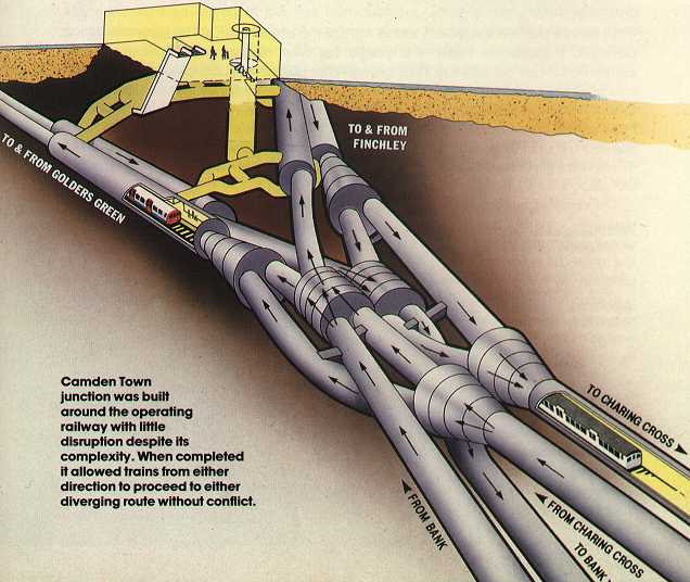
Do you know who has the copyright for this image of Camden Town tunnels? I would like to reproduce.
I don’t know. No. To help follow the trail I’ve just fixed a link above, re-linking the discussion (The URL for which has moved onto archive page number 2 now, which is bad for this kind of link rot) but then the web also lost geocities since I wrote this, so… looking at an archive, where I found the diagram was this old ‘See How They Run’ site. See diagrams linked off the 4th bullet point. There’s no copyright information, other than a wee copyright notice on that whole website. The site seems to be a compilation of images from lots of sources, created by John Francis Rowland. I somehow doubt his email still works: johnr AT turquoisedays.demon.co.uk . …But anyway the images themselves look like they might be scans from a book.