Haiti Earthquake on OpenStreetMap

In last week’s blog post I casually mentioned the Haiti earthquake, and how we had a little project going on, to improve the map of the area on OpenStreetMap. Since then the scale of the disaster has become clearer to me. 200,000 feared dead, and the story has been top of the news headlines all week. In keeping with this, the response by the OpenStreetMap community has been impressive, with massive mapping progress in a very short space of time. What started out for me as a little casual doodling in of streets in Yahoo! imagery, has rapidly turned into a collaboration of hundreds of mappers using post-quake aerial imagery.

Port-au-Prince Haiti on OpenStreetMap
 
Within 48 hours we had a very complete looking map of Port-Au-Prince and Carrefour. Mikel Maron drew attention to this progress with a classic before and after map comparison, and I’ve seen and heard several people expressing surprise and amazement at the speed of the OSM response. Knowing how the community works, I actually didn’t find it that surprising. In fact next time we respond to a disaster, now that people get the idea, I’d hope we could turn around this kind of mapping progress within 12 hours. (or within 12 hours of accessing good imagery).

For me the exciting thing about this past week, has been an increase in recognition of OpenStreetMap as a valuable source of map data. In a scramble to help by providing GIS expertise, many organisations have come to OpenStreetMap as the best source of data. More exciting than that (so amazing!), is to get a message of thanks from some people running search and rescue teams, who have loaded our data onto Garmin units to use on the ground. See Uses of OpenStreetMap data by crisis responders for more examples.

The important point to stress here is that OpenStreetMap is offering map resources covering the Haiti Earthquake in a variety of formats. You can browse the map as conventional fluid web interface, but our open data allows us to do so much more than that.

  • We can offer downloads of raw OSM XML data, ESRI shapefiles, Garmin img. These are listed at the top of that page. Well done to GeoFabrik for responding quickly with their specialised Haiti downloads service
  • Mobile devices across many platforms can make use of our data or map images. See this section and the main ‘Software for mobile devices’ list. People heading to Haiti for rescue and recovery missions, should juice up their devices with this good stuff!
  • We can render the map in different ways. User:Ldp set up haiti.openstreetmap.nl as a custom Mapnik rendering showing building damage and refugee camps. These are special tags invented for the purposes of recording this information using OpenStreetMap’s open tagging approach
  • We can provide rendered maps tiles for use in online apps. Anyone setting up a website e.g. to help with the earthquake response, can display OpenStreetMap maps in much the same way as embedding a google map. (It’s a little known fact that you can even use Google Maps API to display OpenStreetMap tiles. See Google Maps Example)
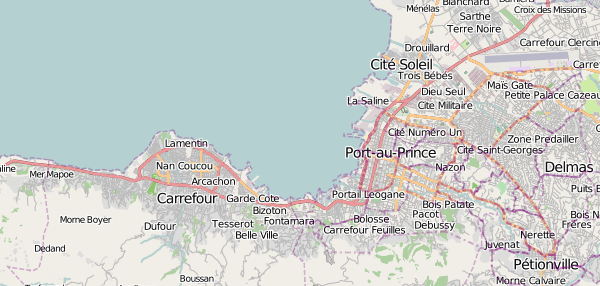
  • We can offer maps files for printing. The list of printable files includes vector formats (SVG and PDF) and high resolution raster images offered by me! This was my main technical contribution over the past week (assuming you don’t count wiki link fiddling as technical!) I set up some hi-res map images of Port-Au-Prince and Carrefour and a script to rebuild the image with updates every hour. At the time I hadn’t noticed GeoFabrik had done the same thing, but they’re covering different areas and larger images, so it’s all a good variety of offerings.
  • We can set up other types of customised geo services for Haiti using OpenStreetMap’s raw data. Check out Open Route Service Haiti and Nominatim Search for Haiti

A lot of these things were possible using the collective expertise of the OpenStreetMap community who, uniquely, have become fully accustomed and experienced with having access to raw map data.

I mentioned 48 hours as an approximate measure of how long things took, but as ever with OpenStreetMap, things are never really complete. The mapping efforts in Haiti are very much ongoing, and you can help! Check out the Haiti project page for details. We’re mainly looking at mapping more outlying country roads, anything new you can find to sketch within the various imagery sources, but also making use of some other sources e.g. street naming from U.S. military maps. If you’re new to OpenStreetMap mapping you’re very welcome to get stuck in, but be prepared to climb a bit of a learning curve with the editing software (set aside an hour)

But we need to get the message out about the map resources I’ve listed above. I think that’s more important than encouraging people to join in with mapping at this stage The Fairfax County Urban Search & Rescue Team in their message said “Please be assured that we are using your data – I just wish we knew about this earlier”.


UPDATE: I’ve written about OpenStreetMap and Google MapMaker in Haiti in relation to the wasted duplication of effort split between the two communities (and relating some other blog posts on the topic here and here and here)

The developing world on OpenStreetMap – Armchair mapping possibilities

One of the most interesting aspects of OpenStreetMap is its global scope. The whole world map is editable wiki-style, and the various techniques for creating maps can work just as well in Niarobi and Nagpur as they do in Newcastle and New York. The project has always been most active in countries like the U.K. where we have lots of commercial map data but want free map data. Often in developing countries there is some commercial map data, so the same considerations apply, but then there are places which have just never been mapped by anyone. It’s quite difficult for me to imagine living in an city without ever seeing a map of that city. But many people do, and presumably they don’t really know what they’re missing. They’re missing a basic information tool for planning development, supply lines, day-to-day life.

Mikel Maron is back from the slums of Nairobi (specifically a massive slum called Kibera) where he has been working with local people on creating the first ever map of the area. His blog post ‘Some notes on Map Kibera mapping‘ gives a hint of some of the amazing stories he has to tell from this experience. No doubt he’ll give another great conference presentation about it.

Kibera Map

He created the Kibera map using OpenStreetMap of course, and I’m proud to say I had a hand in it. He got me to help out from afar, by sending me a link to some high resolution aerial imagery (special imagery which he’d got hold of, which was better than Yahoo!’s), and I traced over some of the basic details, the roads and footways I could see. This was used as a starting point for on-the-ground surveying work which he taught local people how to do. Yesterday Mikel completed the process of uploading all of this onto the main OpenStreetMap server. (See the map)

With OpenStreetMap we can build great maps of developing countries. We can do it ourselves (remote mapping) or local people on the ground can survey the streets. Or some combination of the two. Remote mapping A.K.A. “armchair mapping” by sketching over aerial imagery, is a good way to build a basic map quickly. It’s a sensible first step even if you’re in the area, but of course it doesn’t matter where you are sitting, or which bit of the world you are mapping (although availability of aerial imagery is a limitation) Another point which bears repeating… you don’t need a GPS unit! Gadgets are fun, but armchair mapping is easier and more accessible than that. Anyone with internet connection can get involved.

If you’re looking for ideas of where to do some remote armchair mapping, the Humatarian OpenStreetMap Team page lists some possibilities. Often this involves mapping of disaster zones. At the moment we are trying to quickly improve our map of Haiti after the earthquake which happened there yesterday. Google maps have good coverage, but the hope is that our open licensed maps and open access to the underlying data might be useful in some small way for aid agencies responding in the short term or to local people as they recover from the disaster in the longer term. In addition, we have the potential to produce maps which are more up-to-date (e.g. showing collapsed bridges) if we get some information from people on the ground. We can also map details which google maps don’t normally show, where such things are recognisable from the sky. We’ll need to boost the general completeness of our map before any of that can happen though.

Beyond that, there’s plenty of armchair mapping to do in the developing world. There’s a list of cities with Yahoo Aerial Imagery coverage (We are allowed to use Yahoo!’s imagery for OpenStreetMap) Any city in India could probably do with some help, apart from Chennai which is beautifully mapped!

If you prefer armchair mapping closer to home, there’s things like tracing U.K. rivers from NPE or wade into the big TIGER fixup job in the U.S.

Endless mapping possibilities available directly to you in your armchair, so get stuck in!

Doing the OpenStreetMap jigsaw

Doing the OpenStreetMap jigsaw As a follow up on the OpenStreetMap jigsaw, it seems dad has conquered the 1000 piece beast. Here’s what he had to say about his Christmas present:
“I finally finished the jig-saw the day before yesterday, after several days obsessively working on it. Nearly drove your Mum mad because apart from distracting me from the things she thought were more important, it occupied the dining table for several days. It was certainly quite intriguing, a challenging test of topographical knowledge of London. It would make a good training tool for taxi drivers. The lettering was certainly too small and fuzzy. I found a magnifying glass was useful. But even so it was often unreadable, unless it was a street-name which I half-knew or remembered anyway. I expected it would get easier towards the end, when with a limited number or pieces, it would be possible simply to complete the missing geometry of red, green or orange road patterns. In fact it got more difficult in that respect because the pieces remaining contained fewer distinguishing lines. I finally learned that an effective technique was to examine the lettering on each piece to establish which way up it should go, and carefully keep the pieces orientated correctly even if they couldn’t immediately be fitted. Thus it was possible to key the shapes of the remaining pieces as well as the design on them. I found it a more satisfying puzzle than the 500 piece Turner painting of the Fighting Temeraire, still unfinished from last year’s Christmas. This includes a large number or plain pieces of similar colour, which is ultimately boring unless you’re a jig-saw fanatic.”

So there you have it.  It is do-able. That’s a relief.  I hadn’t thought about the text orientation advantage. I guess that does help a lot.

A couple of people have asked me for more information about how to make your own OpenStreetMap jigsaw, or for help with doing so. It’s pretty tricky. I gave some details in my original post, but I could write some tutorials, or even make software to make it easier.  …Low down on my todo list right now though I’m afraid

Brazil Holiday 2009/2010

In case you missed all my gloating tweets (@harry_wood), I’ve been away in Brazil in the baking summer sunshine for the past three weeks. Here’s some pics:

beansmercado municipalvertical favelasambaSao Paulo tube stationmortadelaplaying with planesIlhabela sunsetkayakingIlhabela guarda solplantssunburnchristmas dinnerskewering chicken heartsGuarhulosdune buggiescoconutFortaleza busy market streetTheatro Jose de AlencarCentro Dragão do Marsand dunesFortaleza new years eve chaosFortaleza new years fireworks 2010Fortaleza beach parkchurrascaria

There’s more on facebook too.

Another great Brazil holiday. I’m starting to get to know the girlfriend’s family a bit better despite not really speaking Portuguese at all.  Spent Christmas with them this time. Lots of amazing food! I can feel a new years resolution coming on… Learn some Portuguese. I gathered a fair bit more mapping data for the São Paulo map, and meeting the other paulistano mappers was a lot of fun. We also got away from São Paulo for some beach time in Ilhabela and Fortaleza. We saw in the new year there, with spectacular fireworks on the beach.

Of course the only year I’ve ever not been at home for Christmas, and the UK has it’s first white Christmas in years. Gah! It’s quite a shock to be back in the cold #uksnow after the heat of Brazil. In fact my baggage didn’t make the flight connection at Madrid on the way home, so I had to head home from heathrow without my big jacket (Given the level of competence on show by the Spanish iberia staff organising connecting flights, this wasn’t a surprise) At first I thought this wouldn’t be a big deal, since I had fortunately stuffed some trousers and a fleece in my hand luggage, but the 10 min walk from my local tube station to my house was a chilly welcome back to the UK. I could feel my sun tan peeling off.

So… 2010!  Happy Christmas and Happy New Year!